


Filters

Stock vector images of Political map europe
Discover royalty-free, professionally-designed vector art of Political map europe for personal and commercial use.

World map with names of sovereign countries and larger dependent territories. Simplified vector map in four shades of green on white background.

Illustration - map of the world with some landmarks.

World map - America centered. Brown orange hue colored on dark background. High detailed political map of World with country, ocean and sea names labeling.

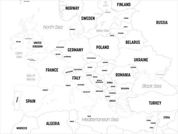
Political map of Europe on a white background, Vector illustration

United States and China highlighted on political map of World. Vector illustration.

Horizontally flipped political map of World. Mirror reflection. Vector illustration.
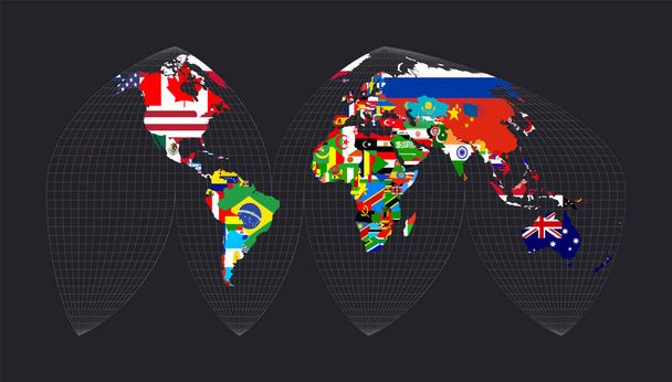
Map of the world with flags. Bogg's interrupted eumorphic projection. Map of the world with meridians on dark background. Vector illustration.

Political map of the world

Arctic region countries and North Pole political map with national borders and country names. Arctic ocean without sea ice. English labeling and scaling. Illustration.

Europe vector political map

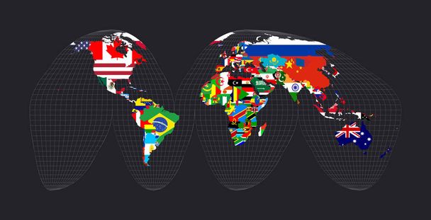
World map with flags. Ginzburg IX projection. Map of the world with meridians on dark background. Vector illustration.

North Europe Region. Map of countries of Scandinavia. Vector illustration.
World map with flags. Goode's interrupted homolosine projection. Map of the world with meridians on dark background. Vector illustration.
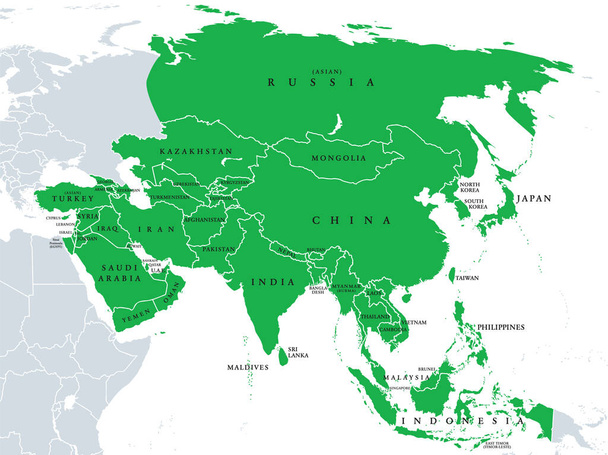
Asia, political map, states and countries of the largest continent. With the Asian part of Russia and Turkey and the Sinai Peninsula as African part. English labeling. Illustration over white. Vector.

Germany vector set. Isolated.

World map with flags. HEALPix projection. Map of the world with meridians on dark background. Vector illustration.

Asia political map with borders and countries. Largest and most populous continent. Gray illustration on white background. English labeling. Vector.

Ireland and Northern Ireland political map with capitals Dublin and Belfast, borders, important cities, rivers and lakes. Island in the North Atlantic Ocean. English labeling. Illustration. Vector.

World map - America centered. Green hue colored on dark background. High detailed political map of World with country, capital, ocean and sea names labeling.

Administrative and political map of the Austrian state of Lower Austria

Greece Political Map. No text. Detailed vector map of Greece.
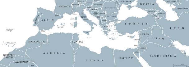
Mediterranean Basin political map. Mediterranean region, also Mediterranea. Lands around Mediterranean Sea. South Europe, North Africa and Near East. Gray illustration with English labeling. Vector.

Spain - Highly detailed editable political map with labeling.
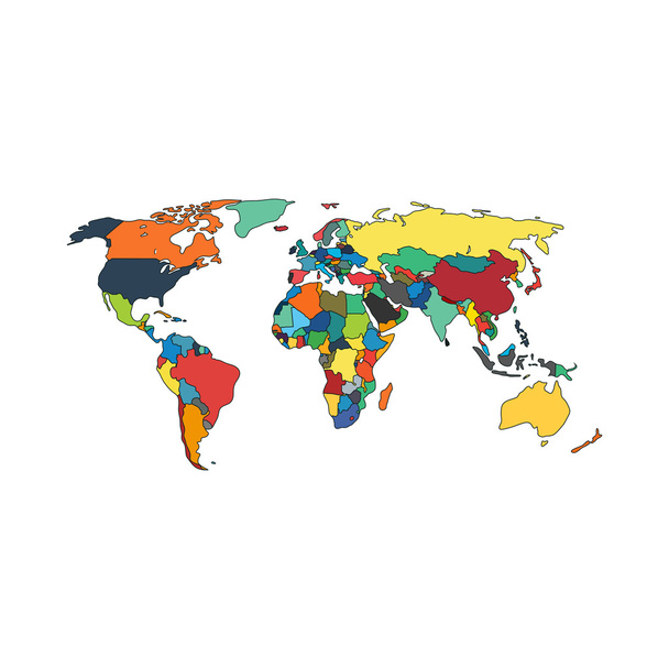
Vector illustration of Political map of world with countries

Denmark political map with capital Copenhagen and neighbor countries. Kingdom, Scandinavian and Nordic country in Europe. Gray illustration with English labeling on white background. Vector.

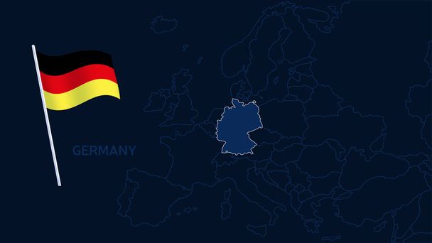
Blue colored Germany outline map. Political german map. Vector illustration map.

Worldmapwithallcountries andtheirflags. Eisenlohr conformal projection. Map of the world with meridians on dark background. Vector illustration.

Europe map - brown orange hue colored on dark background. High detailed political map of european continent with country, ocean and sea names labeling.

World map - America centered. High detailed political map of World with country, capital, ocean and sea names labeling.

Independent Scotland political map with capital Edinburgh, national borders and important cities. Fictive map of Scotland as independent sovereign state after leaving United Kingdom. English labeling.
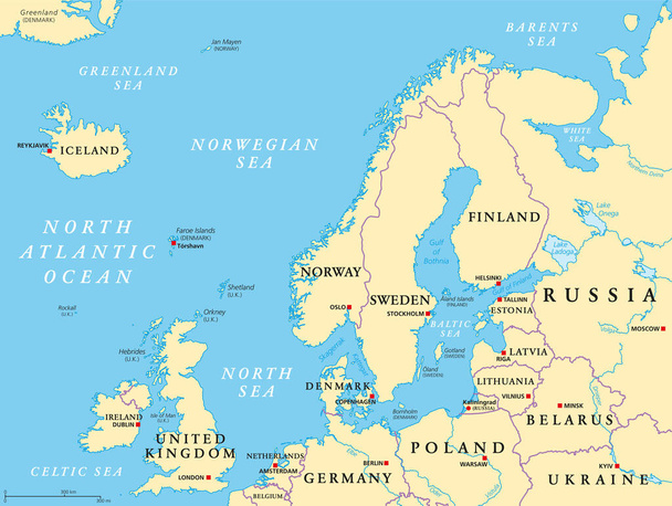
Northern Europe, political map. British Isles, Fennoscandia, Jutland peninsula, Baltic plain lying to the east, and the islands offshore from mainland Northern Europe and the main European continent.

Europe map - brown orange hue colored on dark background. High detailed political map of european continent with country, ocean and sea names labeling.

Colorful London administrative and political map
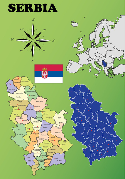
Serbia vector set. Isolated.
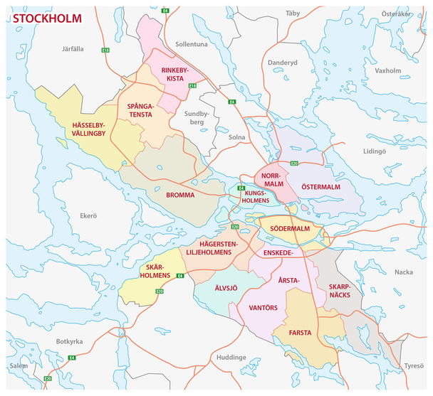
Administrative and political map of the Swedish capital Stockholm

Baltic Sea area countries political map with national borders. Nations and states of Scandinavia. English labeling and scaling. Gray illustration on white background.
Europe map. High detailed political map of european continent with country, capital, ocean and sea names labeling.

World map with flags. Gilbert's two-world perspective projection. Map of the world with meridians on dark background. Vector illustration.
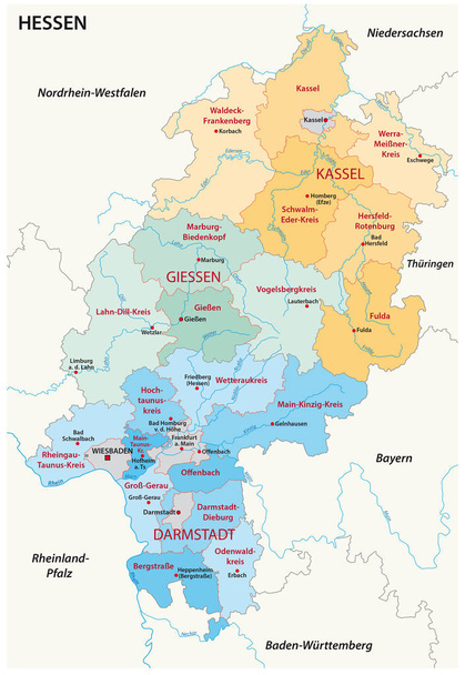
Hesse administrative and political map in german language

Southeast Europe Region. Map of countries of Balkan Peninsula. Vector illustration.
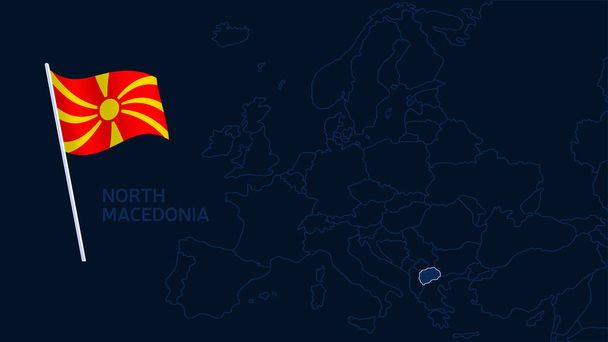
North macedonia on europe map vector illustration. High quality map Europe with borders of the regions on dark background with national flag.
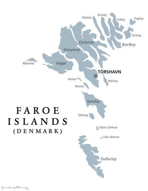
Faroe Islands political map with capital Torshavn, also the Faeroes. Autonomous country and part of the Kingdom of Denmark. Archipelago in North Atlantic. Gray illustration. English labeling. Vector.

Greece political map with capital Athens, with most important peninsulas and islands, with national borders and neighbor countries. Gray colored illustration with English labeling over white.

Svalbard Political Map with capital Longyearbyen, a Norwegian archipelago in the Arctic Ocean, formerly known by its Dutch name Spitsbergen. English labeling and scaling. Illustration.

Vector Earth globe with political map

Denmark Political Map with capital Copenhagen, national borders, important cities and rivers. English labeling and scaling. Illustration.

Spain vector set. Isolated.

Europe map, new political detailed map, separate individual states, with state names, background blackboard school chalkboard vector

Mediterranean Basin Political Map. South Europe, North Africa and Near East with capitals, national borders, rivers and lakes. English labeling and scaling. Illustration.
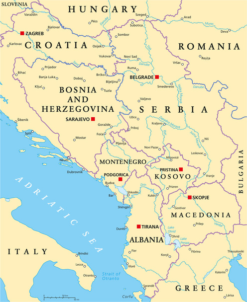
Central Balkan Political Map formed by Bosnia and Herzegovina, Serbia, Montenegro, Kosovo, Albania and Macedonia. With capitals, national borders, important cities, rivers and lakes. English labeling and scaling.

South Europe Region. Map of countries in southern Europe around Mediterranean Sea. Vector illustration.

Union State, member states, political map. Officially the Union State of Russia and Belarus, is a supranational organisation, with the stated aim of deepening the relationship between the two states.

Fennoscandia, Fennoscandian Peninsula, political map. Peninsula, comprising the Scandinavian and Kola Peninsulas, mainland of Finland, Norway and Sweden, Murmansk Oblast, and the Republic of Karelia.

Illustration of a Political Map of Northern Ireland
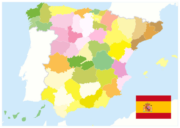
Administrative Political Map of Spain. No text. All elements are separated in editable layers clearly labeled. Vector illustration.

Worldmapwithallcountries andtheirflags. Azimuthal equidistant projection. Map of the world with meridians on dark background. Vector illustration.

Bosporus and Dardanelles, political map. The Turkish Straits, internationally significant and narrow waterways in Turkey. Passages, connecting the Aegean Sea and the Sea of Marmara with the Black Sea.
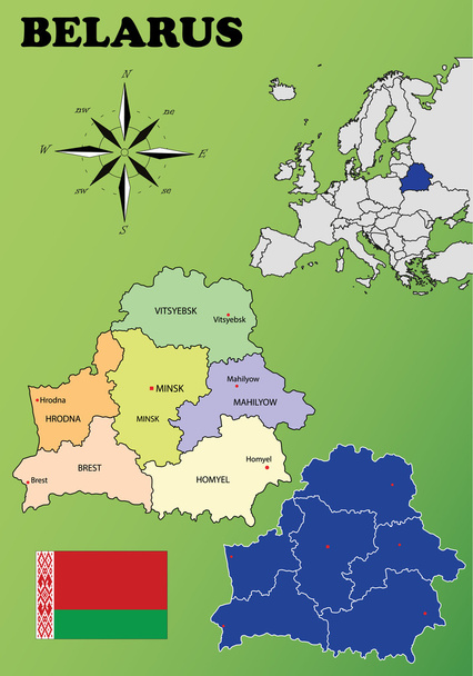
Belarus vector set. Isolated.
Germany on europe map vector illustration. High quality map Europe with borders of the regions on dark background with national flag.

Baltic States and Kaliningrad, political map. From Finland to Estonia, Latvia and Lithuania, to Poland, and from the Russian exclave Kaliningrad Oblast, to Belarus, and to the European Part of Russia.

Austria vector set. Isolated.

Highly detailed editable political map with separated layers. Italy.
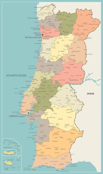
Portugal Political Map Vintage Color - Detailed map of Portugal vector illustration - All elements are separated in editable layers clearly labeled.

Switzerland on europe map vector illustration. High quality map Europe with borders of the regions on dark background with national flag.

World map with flags. Lambert azimuthal equal-area projection. Map of the world with meridians on dark background. Vector illustration.
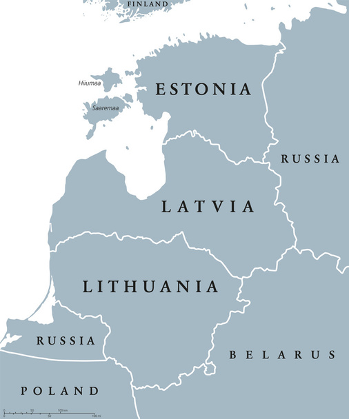
Baltic countries political map, also known as Baltics, Baltic nations or states. Estonia, Latvia and Lithuania with national borders. Gray illustration with English labeling and scaling over white.
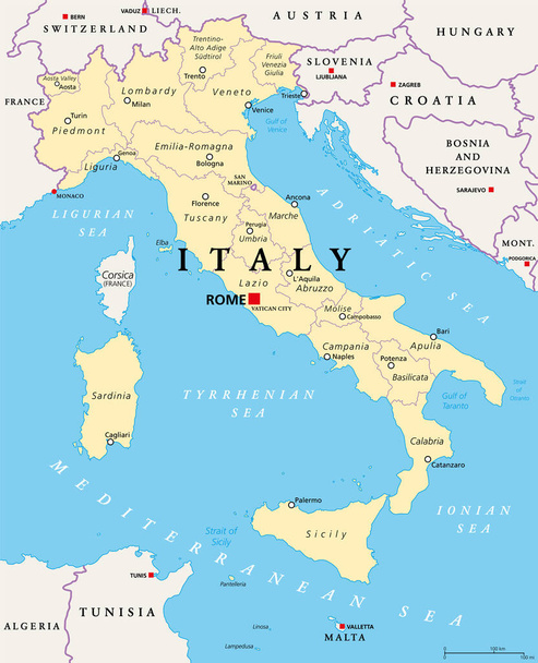
Italy, political map, administrative divisions. Italian Republic with capital Rome, 20 regions and their capitals, international borders and neighbor countries. English labeling. Illustration. Vector.
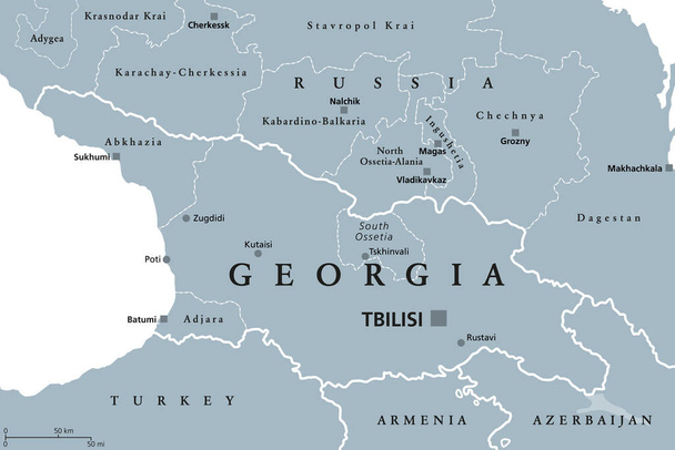
Georgia, gray political map, with capital Tbilisi, and international borders. Republic and transcontinental country in Eurasia, located south of North Caucasus Federal District of Russia. Illustration
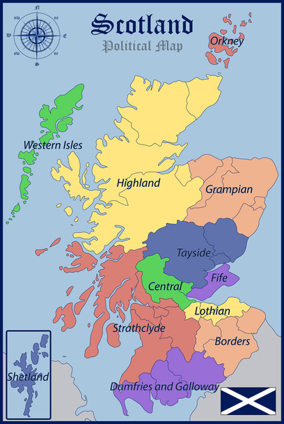
Illustration of a Political Map and Flag of Scotland
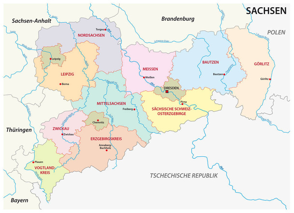
Saxony administrative and political map in german language

England on europe map vector illustration. High quality map Europe with borders of the regions on dark background with national flag.

France, political map with multicolored regions of Metropolitan France. French Republic, capital Paris, administrative regions and prefectures on the mainland of Europe. English. Illustration. Vector.

Administrative and political map of the Austrian state of Carinthia

Netherlands on europe map vector illustration. High quality map Europe with borders of the regions on dark background with national flag.
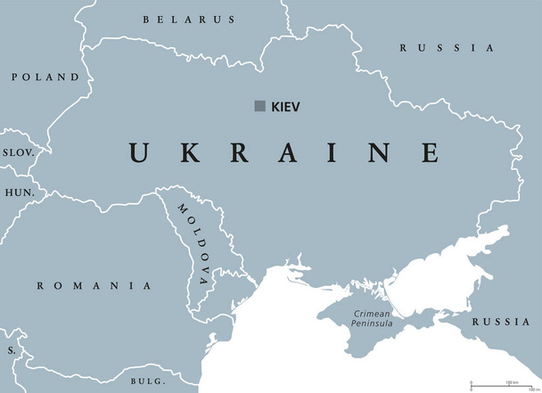
Ukraine political map with capital Kiev, national borders, Crimean Peninsula and neighbor countries. State in Eastern Europe. Gray illustration isolated on white background. English labeling. Vector.
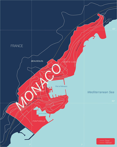
Monaco country detailed editable map with regions cities and towns, roads and railways, geographic sites. Vector EPS-10 file
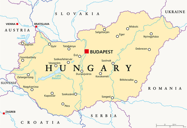
Hungary political map with capital Budapest, national borders, important cities, rivers and lakes. English labeling and scaling. Illustration.
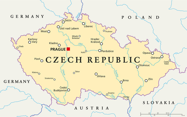
Czech Republic Political Map with capital Prague, national borders, important cities, rivers and lakes. English labeling and scaling. Illustration.

Finland political map with capital Helsinki, national borders and neighbor countries. Republic and state in Northern Europe. Gray illustration, English labeling, isolated on white background. Vector.

Portugal map highlighted in Portugal flag colors, gray map with neighboring countries.

Sao Miguel Island, Azores, Portugal, political map, with capital Ponta Delgada. Nicknamed The Green Island, the largest and most populous island in the Portuguese archipelago of the Azores. Vector.

North Africa region, political map. Yellow colored area, with capitals and borders. Collective term for a group of Mediterranean countries on African continent. English labeling. Illustration. Vector.

Baltic single states political map, known as Baltics, Baltic nations or states. Estonia, Latvia and Lithuania in different colors and with national borders. English labeling, illustration over white.

Caspian Sea region political map with most important cities, borders, rivers and lakes. Body of water, basin, and largest lake on earth between Europe and Asia. Illustration. English labeling. Vector.

Cyprus Political Map with capital Nicosia, national borders, important cities and rivers. English labeling and scaling. Illustration.

The Caucasus, or Caucasia, gray political map. Region between the Black Sea and the Caspian Sea, mainly occupied by Armenia, Azerbaijan, Georgia, and parts of Southern Russia. Map with disputed areas.

Catalonia political map with capital Barcelona, borders and important cities. Autonomous community of Spain on the northeastern extremity of Iberian Peninsula. English labeling. Illustration. Vector.

Isle of Man, also known as Mann, political map. An island nation and British Crown Dependency in the Irish Sea, between Great Britain and Ireland. A tax haven and offshore banking destination. Vector.

Large Hadron Collider (LHC) and Super Proton Synchrotron (SPS), gray political map. Position of the largest and highest-energy particle collider near Geneva beneath the France and Switzerland border.

Channel Islands, political map. The Crown Dependencies Bailiwick of Guernsey and Bailiwick of Jersey, an archipelago in the English Channel, off the coast of France. Remnants of the Duchy of Normandy.

Chechnya, gray political map with capital Grozny and borders. Chechen Republic, a republic of Russia, and part of the North Caucasus Federal District, situated in the North Caucasus of Eastern Europe.

Independent Catalonia political map on the northeastern extremity of Iberian Peninsula. With capital Barcelona, borders and important cities. English labeling. Illustration. Vector.

Latvia political map with capital Riga, national borders, important cities, rivers and lakes. English labeling and scaling. Illustration.

Turkey on europe map vector illustration. High quality map Europe with borders of the regions on dark background with national flag.

Administrative and political map of Region Hannover in German language
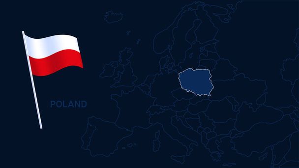
Poland on europe map vector illustration. High quality map Europe with borders of the regions on dark background with national flag.

Balearic Islands political map with capital Palma. Archipelago of Spain in Mediterranean Sea near Iberian Peninsula coast. Majorca, Minorca, Ibiza, Formentera. lllustration. English labeling. Vector

Abruzzo administrative and political map with flag

Catalonia political map with capital Barcelona and borders. Autonomous community of Spain on the northeastern extremity of Iberian Peninsula. English labeling. Gray illustration over white. Vector.

Croatia political map with capital Zagreb, national borders and neighbor countries. Gray illustration with English labeling on white background. Vector.