


Filters

Stock vector images of Political map europe
Discover royalty-free, professionally-designed vector art of Political map europe for personal and commercial use.
Nice europe map isolated on white background
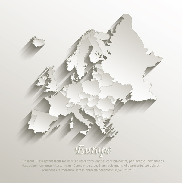
Europe political map card paper 3D natural vector individual states separate

Map of Europe silhouette with country borders isolate on white

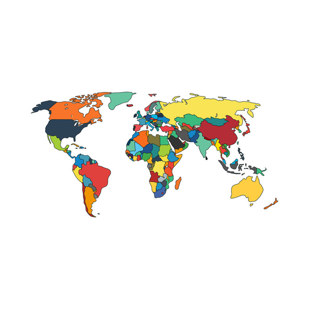
Colorful World political map with clearly labeled, separated layers. Vector illustration.

Highly Detailed Europe Map with the European Union member states highlighted.

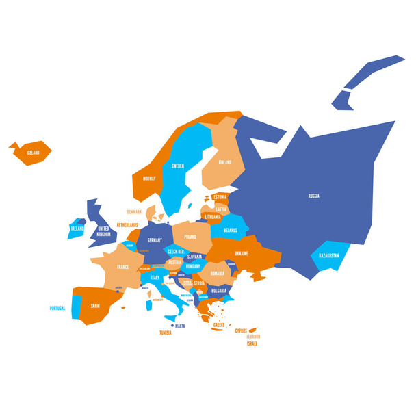
Blank map of Europe with all ministates. Simplified vector map in orange color on white background

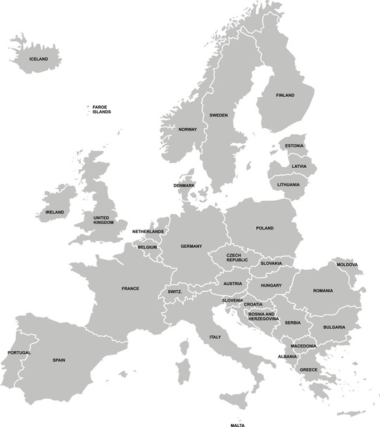
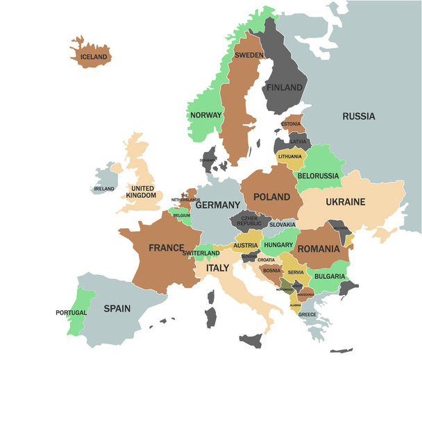
Political map of Europe continent in four shades of green with white country name labels and isolated on white background. Vector illustration.

Political map of Europe continent in four shades of green with white country name labels and isolated on white background. Vector illustration.
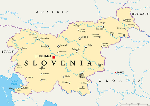
Slovenia political map with capital Ljubljana, national borders, important cities, rivers and lakes. English labeling and scaling. Illustration.

Political map of Europe continent in four shades of maroon with white country name labels and isolated on white background. Vector illustration.

World political map card paper 3D natural vector individual states separate
World Map Vintage Political - Vector Illustration

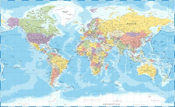
Blue vector world map complete with all countries and capital cities names.

Hand drawn watercolor map of Europe isolated on white. Vector version

Blue colored European states map. Political europe map. Vector illustration map.
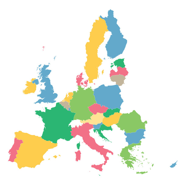
Colorful map of European Union

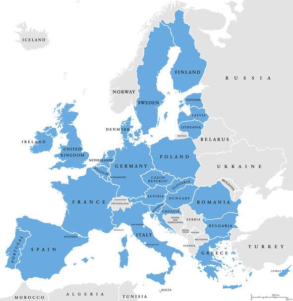
European Union, isolated on white background, with all single countries and English labeling. All 28 EU members, colored in blue. Political and economic union in Europe. Illustration. Vector.
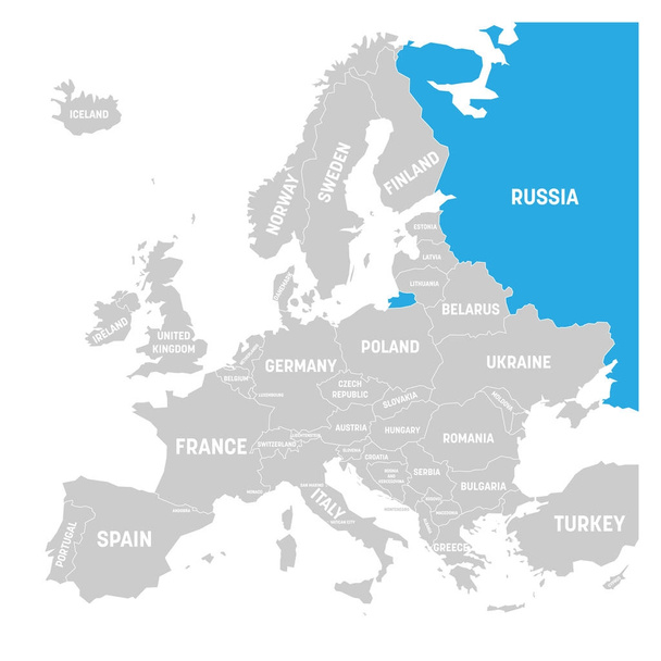
Russia marked by blue in grey political map of Europe. Vector illustration.

World Map - Pacific View - Asia China Center - Political Topographic - Vector Detailed

Railway and political map of Europe and North Africa. European cities. Political map with the border of the states. Urban areas. Railway line.

Political map of Europe, Africa and the Middle East. Political map with the border of the states

World map - America centered. High detailed political map of World with country, capital, ocean and sea names labeling.

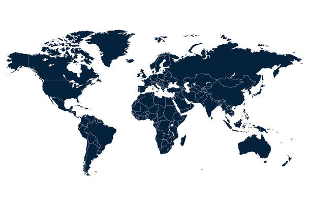
Political map of the world

Illustration - map of the world in vintage style.

Europe with a part of the Middle East, gray political map. Western part of the continent Eurasia, located in the Northern Hemisphere. Countries with international borders and English labeling. Vector

Political map abstract of the world background

Europe, gray political map. Continent and part of Eurasia, located in the Northern Hemisphere, with about 50 sovereign states. Map with borders and English country names. Gray illustration over white.
World map. High detailed political map of World with country, capital, ocean and sea names labeling. Colorful map on dark background.

World map - white lands and grey water. High detailed political map of World with country, capital, ocean and sea names labeling.

Political map of the world
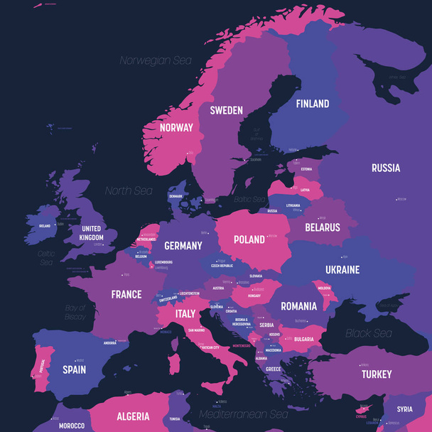
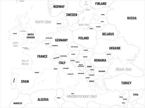
Europe - Political Map of Europe

France marked by blue in grey World political map. Vector illustration.
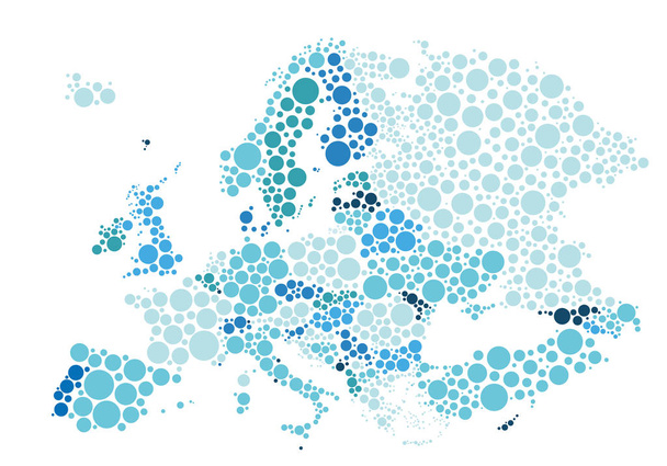
Vector illustration of political map of Europe designed with different sizes and tones of blue dots.

Norway marked by blue in grey World political map. Vector illustration.

Six continents, political world map, with borders. Africa, America, Antarctica, Asia, Australia and Europe. Robinson projection. English labeling. Isolated illustration on white background. Vector.
Europe map. High detailed political map of european continent with country, capital, ocean and sea names labeling.

Map of the world with flags. Interrupted sinusoidal projection. Map of the world with meridians on dark background. Vector illustration.

West Europe Region. Map of countries in western Europe. Vector illustration.

Vatican City State political map. Walled enclave within the city of Rome, Italy. The sovereignty is held by the Holy See. Smallest state in the world. Gray illustration with English labeling. Vector.

World map - grey colored on dark background. High detailed political map of World with country, capital, ocean and sea names labeling.

Blank simplified political map of world with different colors of each continent - North America, South America, Europe, Africa, Asia and Australia. Vector illustration

World map separate individual states green yellow, political map vector

Political map abstract of the world background
World map vector abstract illustration

World map - America centered. White lands and grey water. High detailed political map of World with country, capital, ocean and sea names labeling.
Very simplified infographical political map of Europe. Simple geometric vector illustration.
European Union countries. English labeling. Political map with borders and country names. 28 EU members, colored in light blue. Political and economic union in Europe. Illustration over white. Vector.

World map paper. Political map of the world on a gray background. Countries. Vector illustration. White.

Regions of Europe, political map, with single countries and English labeling. Northern, Western, Southeastern, Eastern, Central, Southern, Southwestern Europe in different colors. Illustration. Vector

Political map abstract of the world. On white background, isolated object

World map with names of sovereign countries and larger dependent territories. Simplified vector map in four shades of green on white background.

Illustration - map of the world with some landmarks.

World map - America centered. Brown orange hue colored on dark background. High detailed political map of World with country, ocean and sea names labeling.

Political map of Europe on a white background, Vector illustration

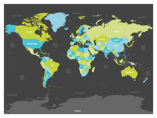
United States and China highlighted on political map of World. Vector illustration.

Horizontally flipped political map of World. Mirror reflection. Vector illustration.
Map of the world with flags. Bogg's interrupted eumorphic projection. Map of the world with meridians on dark background. Vector illustration.

Political map of the world

Arctic region countries and North Pole political map with national borders and country names. Arctic ocean without sea ice. English labeling and scaling. Illustration.

Europe vector political map

World map with flags. Ginzburg IX projection. Map of the world with meridians on dark background. Vector illustration.

North Europe Region. Map of countries of Scandinavia. Vector illustration.
World map with flags. Goode's interrupted homolosine projection. Map of the world with meridians on dark background. Vector illustration.
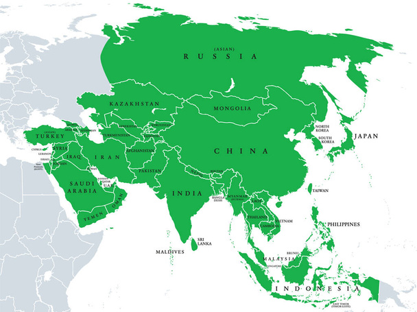
Asia, political map, states and countries of the largest continent. With the Asian part of Russia and Turkey and the Sinai Peninsula as African part. English labeling. Illustration over white. Vector.

Germany vector set. Isolated.

World map with flags. HEALPix projection. Map of the world with meridians on dark background. Vector illustration.

Asia political map with borders and countries. Largest and most populous continent. Gray illustration on white background. English labeling. Vector.

Ireland and Northern Ireland political map with capitals Dublin and Belfast, borders, important cities, rivers and lakes. Island in the North Atlantic Ocean. English labeling. Illustration. Vector.

World map - America centered. Green hue colored on dark background. High detailed political map of World with country, capital, ocean and sea names labeling.

Administrative and political map of the Austrian state of Lower Austria

Greece Political Map. No text. Detailed vector map of Greece.
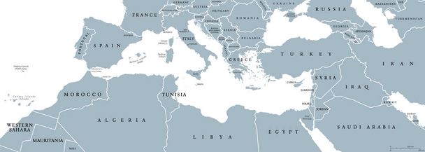
Mediterranean Basin political map. Mediterranean region, also Mediterranea. Lands around Mediterranean Sea. South Europe, North Africa and Near East. Gray illustration with English labeling. Vector.

Spain - Highly detailed editable political map with labeling.
Vector illustration of Political map of world with countries

Denmark political map with capital Copenhagen and neighbor countries. Kingdom, Scandinavian and Nordic country in Europe. Gray illustration with English labeling on white background. Vector.

Blue colored Germany outline map. Political german map. Vector illustration map.

Worldmapwithallcountries andtheirflags. Eisenlohr conformal projection. Map of the world with meridians on dark background. Vector illustration.

Europe map - brown orange hue colored on dark background. High detailed political map of european continent with country, ocean and sea names labeling.

World map - America centered. High detailed political map of World with country, capital, ocean and sea names labeling.

Independent Scotland political map with capital Edinburgh, national borders and important cities. Fictive map of Scotland as independent sovereign state after leaving United Kingdom. English labeling.
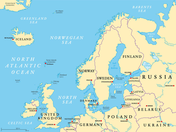
Northern Europe, political map. British Isles, Fennoscandia, Jutland peninsula, Baltic plain lying to the east, and the islands offshore from mainland Northern Europe and the main European continent.

Europe map - brown orange hue colored on dark background. High detailed political map of european continent with country, ocean and sea names labeling.

Colorful London administrative and political map
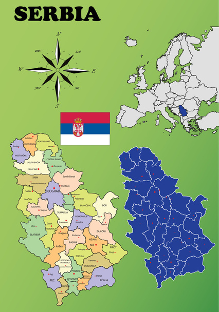
Serbia vector set. Isolated.
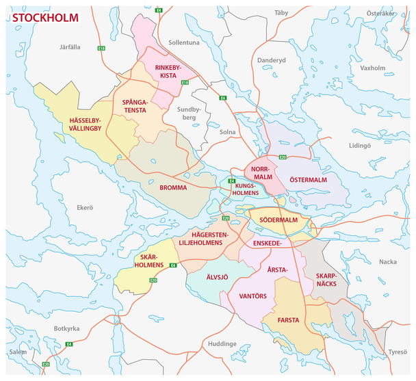
Administrative and political map of the Swedish capital Stockholm

Baltic Sea area countries political map with national borders. Nations and states of Scandinavia. English labeling and scaling. Gray illustration on white background.
Europe map. High detailed political map of european continent with country, capital, ocean and sea names labeling.

World map with flags. Gilbert's two-world perspective projection. Map of the world with meridians on dark background. Vector illustration.
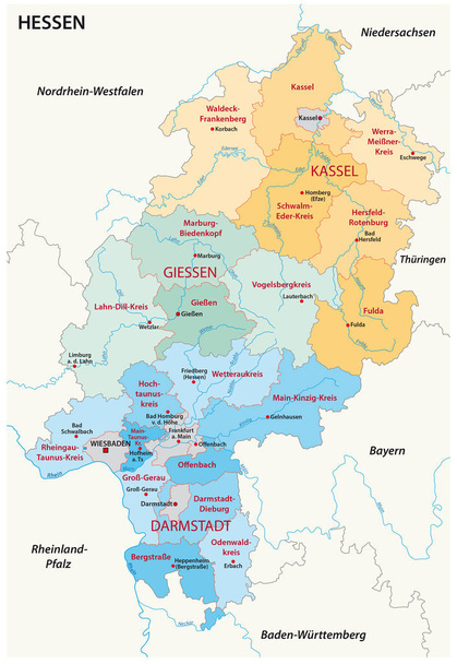
Hesse administrative and political map in german language

Southeast Europe Region. Map of countries of Balkan Peninsula. Vector illustration.
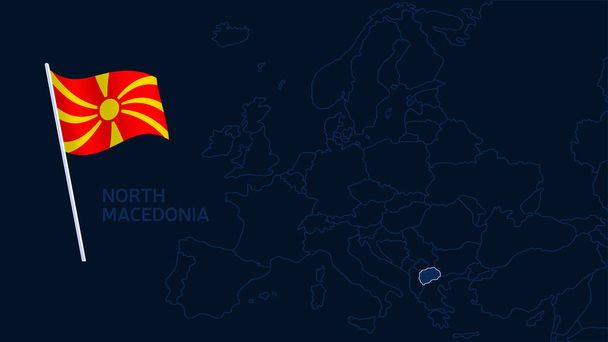
North macedonia on europe map vector illustration. High quality map Europe with borders of the regions on dark background with national flag.
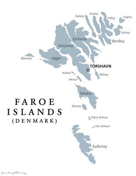
Faroe Islands political map with capital Torshavn, also the Faeroes. Autonomous country and part of the Kingdom of Denmark. Archipelago in North Atlantic. Gray illustration. English labeling. Vector.

Greece political map with capital Athens, with most important peninsulas and islands, with national borders and neighbor countries. Gray colored illustration with English labeling over white.

Svalbard Political Map with capital Longyearbyen, a Norwegian archipelago in the Arctic Ocean, formerly known by its Dutch name Spitsbergen. English labeling and scaling. Illustration.

Vector Earth globe with political map

Denmark Political Map with capital Copenhagen, national borders, important cities and rivers. English labeling and scaling. Illustration.

Spain vector set. Isolated.

Europe map, new political detailed map, separate individual states, with state names, background blackboard school chalkboard vector

Mediterranean Basin Political Map. South Europe, North Africa and Near East with capitals, national borders, rivers and lakes. English labeling and scaling. Illustration.
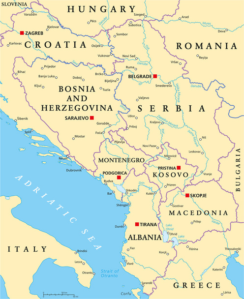
Central Balkan Political Map formed by Bosnia and Herzegovina, Serbia, Montenegro, Kosovo, Albania and Macedonia. With capitals, national borders, important cities, rivers and lakes. English labeling and scaling.