


Filters

Stock royalty-free photos and images of Zuid holland
Discover unlimited high resolution images of Zuid holland and stock visuals for commercial use.

Lamppost, flowers and Marekerk church in the background, Leiden, Netherlands

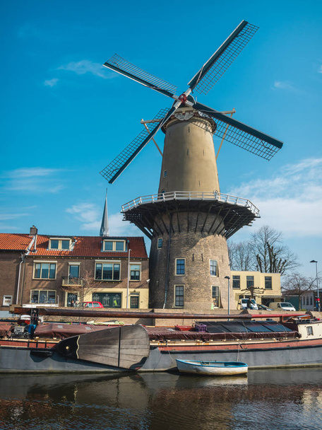
Historic windmill De Valk in the center of Leiden, Holland

Old ship and historic facade in the center of Leiden, Netherlands

Entrance to the main building of the university of Leiden, Netherlands

Aerial view of a flower field in the fog, located between the towns of Lisse and Sassenheim, province of Zuid-Holland, the Netherlands

Little canal and old houses in Gouda, Netherlands

Front facade of the historic town hall in Gouda, Netherlands

Little towers and red shutters on the historic town hall in Gouda, Netherlands

Little towers on the facade of the historic town hall in Gouda, Netherlands

Red shutters on the wall of the historic town hall in Gouda

Old houses at the canal in historic city Gouda, Netherlands

Facades of old brick houses in Haastrecht, Netherlands

Gouda is a city and municipality in the west of the Netherlands

Isolated Dutch city sign of Monster, located in Westland, Zuid-Holland. Place name sign from the Netherlands on white background.

Isolated Dutch city sign of Hardinxveld-Giessendam, located in Hardinxveld-Giessendam, Zuid-Holland. Place name sign from the Netherlands on white background.

Isolated Dutch city sign of Ammerstol, located in Krimpenerwaard, Zuid-Holland. Place name sign from the Netherlands on white background.

Isolated Dutch city sign of Dirksland, located in Goeree-Overflakkee, Zuid-Holland. Place name sign from the Netherlands on white background.

Alphen aan den Rijn, Zuid-Holland vintage street map. Retro Dutch city plan.

Nieuwerkerk aan den IJssel, Zuid-Holland vintage street map. Retro Dutch city plan.

Retro Dutch city map of Waal located in Zuid-Holland. Vintage street map.

Retro Dutch city map of Strijen located in Zuid-Holland. Vintage street map.

Retro Dutch city map of Nieuwe-Tonge located in Zuid-Holland. Vintage street map.

Retro Dutch city map of Puttershoek located in Zuid-Holland. Vintage street map.
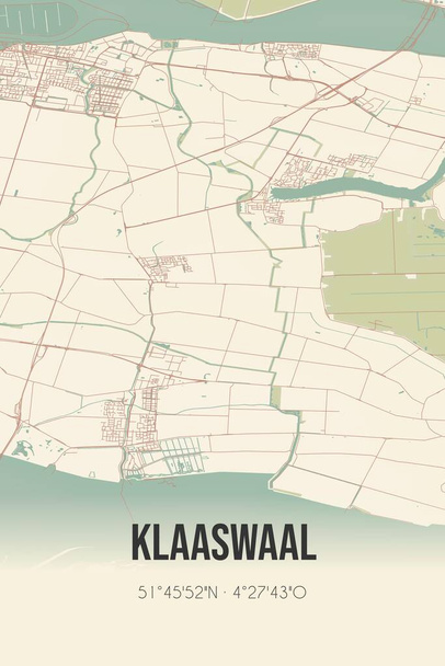
Retro Dutch city map of Klaaswaal located in Zuid-Holland. Vintage street map.

The ' Amsterdamse waterleidingduinen ' is a dune area between Zandvoort (Noord-Holland) and the Langevelderslag in Noordwijk (Zuid-Holland). The Netherlands

The ' Amsterdamse waterleidingduinen ' is a dune area between Zandvoort (Noord-Holland) and the Langevelderslag in Noordwijk (Zuid-Holland). The Netherlands

The ' Amsterdamse waterleidingduinen ' is a dune area between Zandvoort (Noord-Holland) and the Langevelderslag in Noordwijk (Zuid-Holland). The Netherlands

Abstract street map of Mookhoek located in Zuid-Holland municipality of Hoeksche Waard. City map with lines

Abstract street map of Maasdijk located in Zuid-Holland municipality of Westland. City map with lines

Abstract street map of Maasvlakte Rotterdam located in Zuid-Holland municipality of Rotterdam. City map with lines

Abstract street map of Europoort Rotterdam located in Zuid-Holland municipality of Rotterdam. City map with lines

Abstract street map of Vlist located in Zuid-Holland municipality of Krimpenerwaard. City map with lines

Abstract street map of Schipluiden located in Zuid-Holland municipality of Midden-Delfland. City map with lines

Abstract street map of Zoetermeer located in Zuid-Holland municipality of Zoetermeer. City map with lines

Abstract street map of Gouderak located in Zuid-Holland municipality of Krimpenerwaard. City map with lines

Abstract street map of Strijen located in Zuid-Holland municipality of Hoeksche Waard. City map with lines

Retro Dutch city map of Benthuizen located in Zuid-Holland. Vintage street map.

Retro Dutch city map of Bleiswijk located in Zuid-Holland. Vintage street map.

Retro Dutch city map of Schoonhoven located in Zuid-Holland. Vintage street map.

Houses at the river Vlist in Haastrecht, Netherlands

Isolated Dutch city sign of Ottoland, located in Molenlanden, Zuid-Holland. Place name sign from the Netherlands on white background.

Isolated Dutch city sign of Gouderak, located in Krimpenerwaard, Zuid-Holland. Place name sign from the Netherlands on white background.

View of cityscape on the center of the town and Marekerk, Leiden, Netherlands
Gouda is a city and municipality in the west of the Netherlands

Isolated Dutch city sign of Vlist, located in Krimpenerwaard, Zuid-Holland. Place name sign from the Netherlands on white background.

The ' Amsterdamse waterleidingduinen ' is a dune area between Zandvoort (Noord-Holland) and the Langevelderslag in Noordwijk (Zuid-Holland).

Historic Barnabas church in the center of Haastrecht, Netherlands

Historic windmill Slot in the center of Gouda, Netherlands

Retro Dutch city map of Moerkapelle located in Zuid-Holland. Vintage street map.

Retro Dutch city map of Oegstgeest located in Zuid-Holland. Vintage street map.

Retro Dutch city map of Rijpwetering located in Zuid-Holland. Vintage street map.

Abstract street map of Wassenaar located in Zuid-Holland municipality of Wassenaar. City map with lines

Abstract street map of Vierpolders located in Zuid-Holland municipality of Brielle. City map with lines

Abstract street map of Heerjansdam located in Zuid-Holland municipality of Zwijndrecht. City map with lines

Abstract street map of Kwintsheul located in Zuid-Holland municipality of Westland. City map with lines

Abstract street map of Oud-Beijerland located in Zuid-Holland municipality of Hoeksche Waard. City map with lines

Abstract street map of Puttershoek located in Zuid-Holland municipality of Hoeksche Waard. City map with lines

Abstract street map of Langerak located in Zuid-Holland municipality of Molenlanden. City map with lines

Abstract street map of Noordwijk located in Zuid-Holland municipality of Noordwijk. City map with lines

Abstract street map of Gouda located in Zuid-Holland municipality of Gouda. City map with lines

Abstract street map of Sommelsdijk located in Zuid-Holland municipality of Goeree-Overflakkee. City map with lines
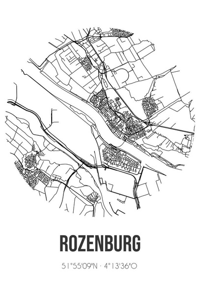
Abstract street map of Rozenburg located in Zuid-Holland municipality of Rotterdam. City map with lines
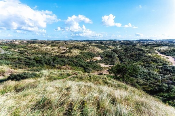
The ' Amsterdamse waterleidingduinen ' is a dune area between Zandvoort (Noord-Holland) and the Langevelderslag in Noordwijk (Zuid-Holland). The Netherlands

Hillegom, Zuid-Holland vintage street map. Retro Dutch city plan.

Abbenbroek, Zuid-Holland vintage street map. Retro Dutch city plan.

Dordrecht, Zuid-Holland, Randstad region vintage street map. Retro Dutch city plan.

Retro Dutch city map of Melissant located in Zuid-Holland. Vintage street map.

Retro Dutch city map of Rhoon located in Zuid-Holland. Vintage street map.

Main building of the university of Leiden, Netherlands

Gouda is a city and municipality in the west of the Netherlands

Isolated Dutch city sign of Piershil, located in Hoeksche Waard, Zuid-Holland. Place name sign from the Netherlands on white background.

Isolated Dutch city sign of Voorburg, located in Leidschendam-Voorburg, Randstad, Zuid-Holland. Place name sign from the Netherlands on white background.

Isolated Dutch city sign of Hoek van Holland, located in Rotterdam, Randstad, Zuid-Holland. Place name sign from the Netherlands on white background.

Isolated Dutch city sign of Maasdijk, located in Westland, Zuid-Holland. Place name sign from the Netherlands on white background.

Isolated Dutch city sign of Ter Aar, located in Nieuwkoop, Zuid-Holland. Place name sign from the Netherlands on white background.

Isolated Dutch city sign of Achthuizen, located in Goeree-Overflakkee, Zuid-Holland. Place name sign from the Netherlands on white background.

Abstract street map of Leiderdorp located in Zuid-Holland municipality of Leiderdorp. City map with lines

Abstract street map of Reeuwijk located in Zuid-Holland municipality of Bodegraven-Reeuwijk. City map with lines

Abstract street map of Heinenoord located in Zuid-Holland municipality of Hoeksche Waard. City map with lines

Abstract street map of Mijnsheerenland located in Zuid-Holland municipality of Hoeksche Waard. City map with lines

Abstract street map of Nieuwkoop located in Zuid-Holland municipality of Nieuwkoop. City map with lines

Abstract street map of Rhoon located in Zuid-Holland municipality of Albrandswaard. City map with lines

Abstract street map of Rijnsaterwoude located in Zuid-Holland municipality of Kaag en Braassem. City map with lines

Retro Dutch city map of Piershil located in Zuid-Holland. Vintage street map.

Aarlanderveen, Zuid-Holland vintage street map. Retro Dutch city plan.

Retro Dutch city map of Oud-Beijerland located in Zuid-Holland. Vintage street map.

Retro Dutch city map of De Zilk located in Zuid-Holland. Vintage street map.

Retro Dutch city map of Rozenburg located in Zuid-Holland. Vintage street map.

Colorful historic house in the center of Gouda, Netherlands

Red shutters on the wall of the historic town hall in Gouda

Tower of the historic reformed church in Haastrecht, Netherlands

Pond in front of the historic royal stables in Den Haag, Netherlands

Entrance gate to the national parliament in Den Haag, Netherlands

Front of the Pieterskerk church in the center of Leiden, Netherlands

Historic windmill De Valk in the center of Leiden, Holland

City limit sign of Rotterdam, The Netherlands isolated on a white background

Isolated Dutch city sign of Hoornaar, located in Molenlanden, Zuid-Holland. Place name sign from the Netherlands on white background.

View of the dome of the Mare kerk, church in the center of the town and lamppost, Leiden, Netherlands

Gouda is a city and municipality in the west of the Netherlands

Isolated Dutch city sign of Hoogvliet Rotterdam, located in Rotterdam, Randstad, Zuid-Holland. Place name sign from the Netherlands on white background.